

- Use Cases
- Data Analysis Data Visualization
- Pricing
- Free
- Ideal For
- Data Analysts Researchers
Overview
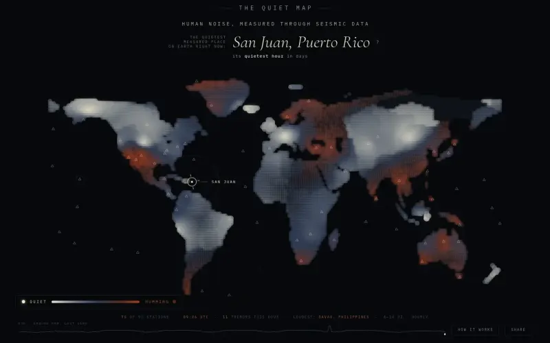
The Quiet Map is a live, hourly-updated map that pinpoints the quietest place on Earth, using data from over 100 seismometers to measure human noise levels. It helps users understand and visualize the impact of human activity on the environment, making it a valuable tool for researchers, scientists, and anyone interested in the intersection of human behavior and the natural world.
The Quiet Map works by analyzing data from a network of seismometers that detect ground vibrations, including those caused by human activities such as traffic, trains, and footsteps. By comparing this data to each station's normal levels, the map identifies areas where the ground has gone quietest, providing a unique perspective on the relationship between human activity and the environment.
Details
Key Features
- Hourly updates using data from over 100 seismometers worldwide
- Real-time measurement of human noise levels, including traffic, trains, and footsteps
- Comparison of current noise levels to each station's normal levels to identify areas of unusual quiet
- Interpolation between seismometer stations to create a comprehensive map of quiet areas
Best For
- Researchers studying the impact of human activity on the environment
- Scientists interested in seismology and geophysics
- Anyone curious about the relationship between human behavior and the natural world
Top Use Cases
- Tracking changes in human activity and their impact on the environment
- Identifying areas of unusual quiet or noise
- Exploring the relationship between human behavior and natural phenomena like earthquakes and volcanic eruptions
Integrations
- The Quiet Map uses data from the Global Seismographic Network (IRIS/EarthScope) and integrates with the USGS live feed to provide additional information on earthquakes and other natural phenomena
Pros
- hourly updates
- real-time measurement of human noise levels
- comprehensive map of quiet areas
- simulation of quiet areas where data is unavailable
Limitations
- limited to areas with seismometer coverage
- interpolation between stations may not always be accurate
Read full editorial notes
What is The Quiet Map?
The Quiet Map is a web-based tool that uses seismometer data to create a live map of the quietest places on Earth, updated every hour. It provides a visual representation of the impact of human activity on the environment, allowing users to explore and understand the relationship between human behavior and the natural world.
What are the key features of The Quiet Map?
Hourly updates using data from over 100 seismometers worldwide
Real-time measurement of human noise levels, including traffic, trains, and footsteps
Comparison of current noise levels to each station's normal levels to identify areas of unusual quiet
Interpolation between seismometer stations to create a comprehensive map of quiet areas
Simulation of quiet areas where seismometer data is unavailable
Who is The Quiet Map best for?
Researchers studying the impact of human activity on the environment
Scientists interested in seismology and geophysics
Anyone curious about the relationship between human behavior and the natural world
What can you use The Quiet Map for?
Tracking changes in human activity and their impact on the environment
Identifying areas of unusual quiet or noise
Exploring the relationship between human behavior and natural phenomena like earthquakes and volcanic eruptions
How does The Quiet Map compare to alternatives?
Unlike other environmental monitoring tools, The Quiet Map focuses specifically on human noise levels and their impact on the environment
While other maps may provide static or infrequently updated data, The Quiet Map offers real-time updates every hour
What integrations and ecosystem support does The Quiet Map offer?
The Quiet Map uses data from the Global Seismographic Network (IRIS/EarthScope) and integrates with the USGS live feed to provide additional information on earthquakes and other natural phenomena
What are the pros and limitations of The Quiet Map?
Pros: hourly updates; real-time measurement of human noise levels; comprehensive map of quiet areas; simulation of quiet areas where data is unavailable
Limitations: limited to areas with seismometer coverage; interpolation between stations may not always be accurate
Built with
Keep researching The Quiet Map
Explore relevant products with a similar category, audience, or use case.


Launched
Ownership
If this is your product, contact us and we can help transfer it to you.
 ChatGPT,
 Claude,
 Perplexity,
 Gemini